

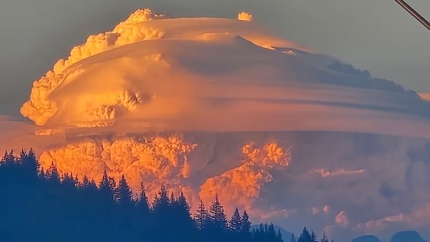

Photos of massive cauliflower-shaped clouds have been appearing on social media in the Vancouver area, identified as pyrocumulus clouds resulting from a wildfire located over 200 kilometers away. The Anderson Creek fire was detected by aircraft responding to nearby fires on Tuesday and rapidly intensified due to strong winds.
According to Environment Canada meteorologist Matt Loney, each fire generates significant heat, and the Anderson Creek fire experienced rapid escalation. These images circulating on social media platforms depict towering cumulus clouds above dark smoke plumes, captured from locations as distant as Coquitlam, approximately 220 kilometers away.
Loney explains that any source of intense heat creating strong convection currents can lead to these clouds, formed as hot air rises rapidly and moisture condenses. He likens this process to opening a freezer door on a scorching summer day, causing fog to descend due to the cold air sinking as the heat rises.
The clouds contain various particles like burning embers, dust, and ashes, visible to the naked eye. As the cloud reaches a certain warmth level and cannot ascend further, it spreads horizontally. The vertical growth of the pyrocumulus cloud from the Boston Bar-area fire indicates the high heat intensity and atmospheric instability, making it visible from multiple angles.
Rachel White, an atmospheric sciences assistant professor at the University of British Columbia, finds the Fraser Canyon cloud images both impressive and unsettling. While she has not personally witnessed these pyrocumulus clouds, she expresses interest in observing one scientifically to understand the wildfires’ power better.
White notes the potential danger of these clouds producing thunderstorms with lightning, which could spark additional wildfires. The occurrence of lightning within these cloud systems is contingent on the specific conditions in the area, highlighting the unpredictable and hazardous nature of these phenomena.