

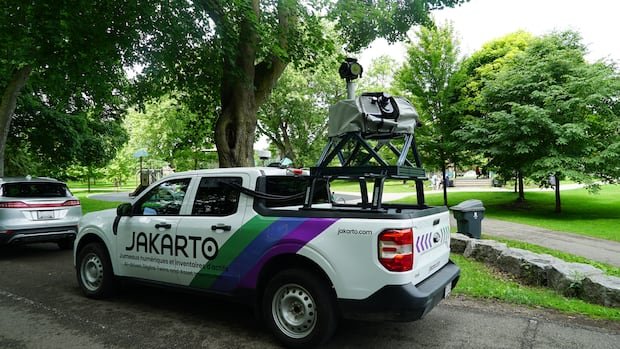

In recent weeks, residents of Guelph have observed vehicles similar to Google Street View cars driving around neighborhoods equipped with large cameras. These trucks are conducting a comprehensive data collection exercise involving millions of laser measurements of trees lining the streets to establish an intricate three-dimensional virtual representation of the city’s tree population. Guelph’s program manager for forestry and sustainable landscapes, Dave Beaton, highlighted that this initiative aims to enhance the city’s management of trees and align with the objective of achieving 40% tree canopy coverage by 2070.
Updating the city’s tree inventory, which currently dates back about 12 years, is crucial as trees undergo growth, removal, and replanting activities over time. The new data collection system promises a more precise and up-to-date assessment of urban trees, influencing long-term planning decisions significantly. The trucks utilize mobile LiDAR scanners to capture detailed information such as tree height, trunk diameter, canopy size, and position, along with details on surrounding infrastructure like signs and hydrants.
Partnering with Quebec-based mapping company Jakarto, the project ensures the careful collection of data visible from public roads, with privacy measures like automatic blurring of license plates. The gathered information will aid in identifying optimal planting locations, enhancing future planning strategies, and targeting areas with inadequate canopy cover. Beaton anticipates that within two months, Guelph will possess an updated tree inventory and a comprehensive 3D virtual map of the city’s urban trees and infrastructure, a task that would have been considerably more time-consuming using traditional methods.
The resulting map, known as a “digital twin,” serves as an advanced model of the city’s urban environment, providing city staff with efficient tools for measurements and infrastructure inspections without physical fieldwork. Felix LaRoche, founder and CEO of Jakarto, emphasized the precision achieved through the collection of two million measurements per second during the scanning process. This technology has been successfully applied in other cities like Cambridge for urban planning and development purposes, enhancing the visual representation of proposed developments within the cityscape.
Guelph’s ambitious goal of achieving 40% tree canopy coverage by 2070 requires significant tree planting efforts, with nearly three million trees estimated to currently exist in the city. The project’s data collection will expedite tree planting initiatives to enhance the city’s resilience to climate change by providing essential shade and cooling effects. Beaton stressed the importance of preparing for the future challenges posed by climate change and the necessity for increased greenery in urban environments.